Headline
Life-threatening conditions seen as ST Nando nears Babuyan Islands
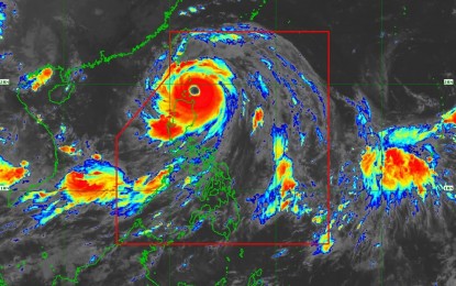
Photo: PAGASA
By Ma. Cristina Arayata, Philippine News Agency
MANILA – The state weather bureau on Monday warned of life-threatening conditions in the northern portion of Northern Luzon as Super Typhoon Nando moved closer to Babuyan Islands.
The Philippine Atmospheric, Geophysical and Astronomical Services Administration (PAGASA) said Babuyan Islands remain under Signal No. 5, facing an “extreme threat to life and property.”
As of 10 a.m., Nando was located 110 kilometers east of Calayan, Cagayan, carrying maximum sustained winds of 215 kilometers per hour (kph) near the center and gustiness of up to 265 kph.
It is forecast to pass close or make landfall over Babuyan Islands between noon and early afternoon.
Typhoon-force winds will also be experienced in areas under Signal No. 4: southern portion of Batanes (Basco, Mahatao, Ivana, Uyugan, Sabtang), the northern of mainland Cagayan (Santa Ana, Santa Praxedes, Claveria, Sanchez-Mira, Pamplona, Abulug, Ballesteros, Aparri, Buguey, Santa Teresita, Gonzaga, Camalaniugan), and the northern portion of Ilocos Norte (Pagudpud, Burgos, Bangui, Dumalneg, Adams).
Areas under Signal No. 3 will experience storm-force winds: the rest of Batanes, the central portion of mainland Cagayan (Lal-Lo, Gattaran, Baggao, Alcala, Santo Niño, Lasam, Allacapan, Rizal, Amulung, Piat), the northern and central portions of Apayao (Flora, Santa Marcela, Pudtol, Luna, Calanasan, Kabugao), and the rest of Ilocos Norte.
Gale-force winds will prevail in areas under Signal No. 2: the rest of mainland Cagayan, Isabela, the rest of Apayao, Abra, Kalinga, Mountain Province, Ifugao, the northern portion of Benguet (Mankayan, Buguias, Bakun, Kibungan), the northeastern portion of Nueva Vizcaya (Diadi), Ilocos Sur, and the northern portion of La Union (Sudipen, Bangar, Luna, Balaoan, Santol).
Strong winds will prevail in areas under Signal No. 1: Quirino, the rest of Nueva Vizcaya, the rest of Benguet, the rest of La Union, Pangasinan, Aurora, Nueva Ecija, Bulacan, Tarlac, Pampanga, Zambales, and the northern portion of Quezon (General Nakar) including Polillo Islands.
The southwest monsoon and Nando’s trough are expected to bring strong to gale-force gusts across Metro Manila, Central Luzon, Calabarzon, Bicol Region, Mimaropa, the Visayas, and Mindanao.
A gale warning is in effect over the seaboards of Northern Luzon and the eastern seaboard of Central Luzon.
PAGASA also warned of a high risk of life-threatening storm surge, with peak heights exceeding three meters within the next 24 hours, threatening low-lying or exposed coastal areas in Batanes, Cagayan (including Babuyan Islands), Ilocos Norte, and Ilocos Sur.
Meanwhile, Nando is expected to dump heavy rains over Batanes, Cagayan, Ilocos Norte, Ilocos Sur, Abra, Apayao, La Union, Benguet, Mountain Province, Kalinga, Isabela, Pangasinan, Ifugao, Nueva Vizcaya, Nueva Ecija, Tarlac, Pampanga, Bulacan and Zambales.