Headline
Typhoon ‘Chedeng’ weakens slightly — PAGASA
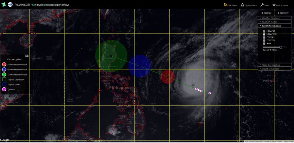
#ChedengPH via Met-Hydro Decision Support Infosys (MDSI)
MANILA — Typhoon “Chedeng” has weakened slightly while continuing to move over the Philippine Sea in a west-northwest direction, according to the Philippine Atmospheric, Geophysical and Astronomical Services Administration (PAGASA) on Thursday.
In its 11 a.m. weather bulletin, PAGASA said that as of 10 a.m., typhoon Chedeng was located based on all available data at 995 kilometers east of Catarman, Northern Samar or 915 km east-northeast of Borongan, Eastern Samar (12.
4°N, 133.8°E).
The weather agency said that due to vertical wind shear, the typhoon’s maximum sustained winds decreased from 180 kilometers to 175 kph near the center and its gustiness also weakened from 215 kph to 210 kph.
It is forecast to move-west northwest at 19 kph.
If it maintains its speed and movement, PAGASA weather forecaster Jori Loiz said the typhoon is expected to make landfall over the eastern coast of Aurora or Isabela by late Saturday (April 4) to early Sunday (April 5).
The public is alerted against possible flashfloods over low-lying areas and landslides along mountain slopes, particularly over Aurora-Isabela area.
Within the next 12 hours, PAGASA is expected to raise Public Storm Warning Signal No. 1 over the Bicol and Samar provinces. Hence, sea travel over these areas will be possibly suspended.
The estimated rainfall amount is from moderate to heavy within the 150 to 200-km radius of the typhoon.
Storm surges and sea surface waves of up to our meters are possible over the eastern coast of Samar, Bicol and Aurora-Quezon.
Fisherfolks are advised not to venture out over the eastern seaboard of the Bicol Region and of the Visayas.
Typhoon Chedeng is forecast to be at 740 km east of Daet, Camarines Norte by Friday.
By Saturday morning, it is expected to be at 595 km east of Virac, Catanduanes and by Sunday morning it is estimated to be at 130 km northeast of Baguio City.