Headline
‘Julian’ now a super typhoon
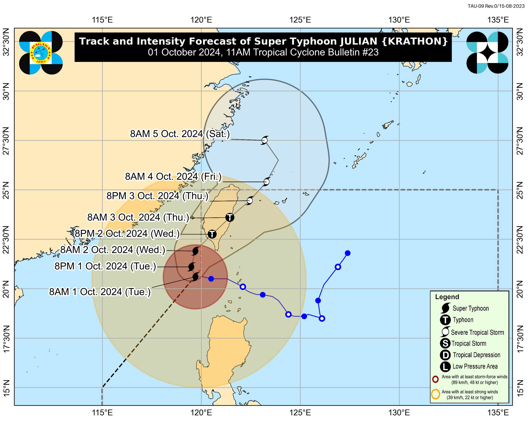
Track and intensity forecast of Super Typhoon Julian (Photo: Dost_pagasa/Facebook)
MANILA – Weather disturbance Julian has intensified into a super typhoon, packing maximum sustained winds of 185 kilometers per hour (kph) near the center and gustiness of up to 230 kph, the weather bureau said Tuesday.
Julian was last seen 205 kilometers (km) west of Itbayat, Batanes, moving slowly west northwestward.
Tropical cyclone wind signal (TCWS) no. 2 is hoisted over Batanes, Babuyan Islands, the northern portion of Ilocos Norte (Bacarra, Pasuquin, Bangui, Vintar, Burgos, Pagudpud, Dumalneg, Adams), and the northwestern portion of mainland Cagayan (Santa Praxedes, Claveria, Sanchez-Mira). Gale-force winds will be experienced in these areas.
Strong winds will prevail in areas under TCWS no. 1 hoisted over the rest of Ilocos Norte, Ilocos Sur, La Union, Pangasinan, Apayao, Kalinga, Abra, Mountain Province, Ifugao, Benguet, the rest of mainland Cagayan, Isabela, Quirino, Nueva Vizcaya, the northern portion of Aurora (Dilasag, Casiguran, Dinalungan), and the northern portion of Nueva Ecija (Carranglan, Lupao, Pantabangan).
Strong to gale-force gusts are also forecast in Ilocos Region, Cordillera Administrative Region, the northern and eastern portions of mainland Cagayan, the eastern portion of Isabela, Aurora, Zambales, Bataan, Metro Manila, Calabarzon, Romblon, and Camarines Norte.
The Philippine Atmospheric, Geophysical and Astronomical Services Administration (PAGASA) said there is a moderate to high risk of life-threatening storm surge in the next 48 hours over the low-lying or exposed coastal localities of Batanes and Babuyan Islands.
Gale warning is hoisted over the northern and western seaboards of Northern Luzon.
Sea travel is risky for all all types or tonnage of vessels.
PAGASA, meanwhile, said Julian still has a window for brief intensification in the next 24 hours.
The super typhoon is forecast to exit the Philippine Area of Responsibility on Thursday afternoon or evening.
Over 22K families affected
The National Disaster Risk Reduction and Management Council (NDRRMC) reported on Tuesday that the super typhoon has affected some 22,645 families in three regions.
In its situation update, the disaster response body said these families are equivalent to 77,249 persons residing in 252 barangays in the Cordillera Administrative Region (CAR), Ilocos Region, and Cagayan Valley.
There are no reports of casualties so far.
Around 254 families or 762 individuals are being aided inside 38 evacuation centers while another 327 families or 1,031 persons are being helped outside.
Some 38 houses were damaged due to the effects of Julian in the Ilocos Region and CAR.