Breaking
Typhoon ‘Florita’ to exit PAR on Tuesday; continues to enhance ‘habagat’ — PAGASA
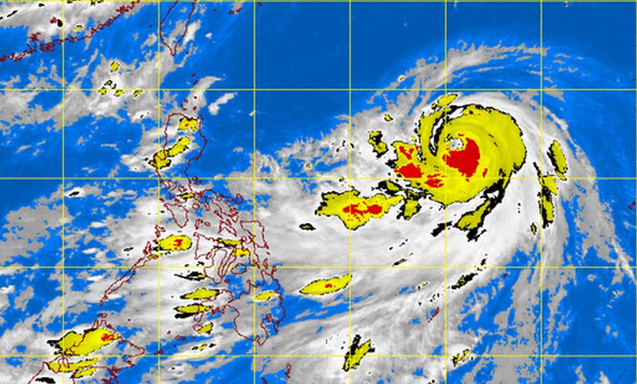
MANILA — Typhoon “Florita” is expected to be out of the Philippine Area of Responsibility (PAR) on Tuesday afternoon but continues to enhance the southwest monsoon that will induce rains in most parts of the country, according to the Philippine Atmospheric, Geophysical and Astronomical Services Administration (PAGASA).
In an interview, PAGASA weather forecaster Julie Nimes said that as 4 p.m. Monday, the eye of the typhoon was located based on all available data at 500 east-northeast of Basco, Batanes (22.0°N, 127.0°E), packed with maximum sustained winds of 195 kilometers per hour (kph) and gustiness of up to 230 kph.
Nimes said typhoon “Florita” is not expected to make landfall in any part of the country.
She added that the typhoon continues to move north-northwest at 20 kph toward Okinawa, Japan.
With its speed and movement, Nimes said the typhoon is expected to be out of the PAR by Tuesday at 2 p.
m.
She added that once it exits the PAR, it is not expected to recurve or return to the country.
In the next 24 hours, Nimes said Western Visayas, Mimaropa (Mindoro, Marinduque, Romblon and Palawan) and the provinces of Zambales, Bataan, Cavite and Batangas will have monsoon rains.
She added that Metro Manila and the rest of Luzon and of the Visayas will experience occasional rains while Mindanao will have partly cloudy to cloudy skies with isolated rainshowers or thunderstorms.
The weather bureau also issued gale warning as strong to gale force winds associated with the surge of the southwest monsoon enhanced by typhoon “Florita” is expected to affect the northern and eastern seaboard of Luzon and the eastern and central seaboard of the Visayas.
“Fishing boats and other small sea crafts are advised not to venture out into the sea while larger sea vessels are alerted against big waves,” it said.


