Breaking
TS ‘Inday’ now outside the PAR; continues to enhance ‘hanging habagat’
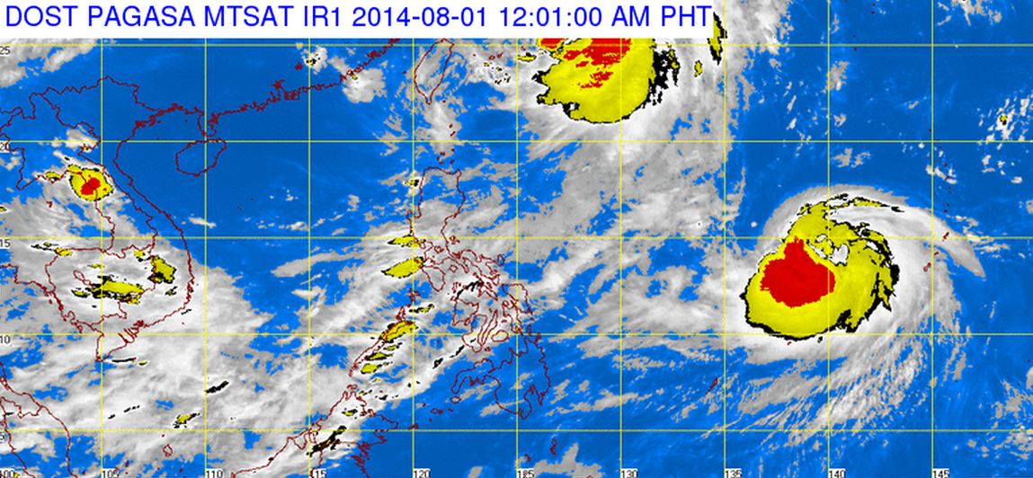
MANILA — Tropical storm “Inday” is now outside the Philippine Area of Responsibility (PAR) but continues to enhance the southwest monsoon or “hanging habagat” that is inducing rains in most parts of the country, the Philippine Atmospheric, Geophysical and Astronomical Services Administration (PAGASA) said Thursday afternoon.
In an interview, PAGASA weather forecaster Meno Mendoza said that TS “Inday” left the PAR at around 3 p.m. and continued to move north-northwest at 20 kilometers per hour toward Japan.
He said that as of 4 p.m., “Inday” was located at 660 km northeast of Basco, Batanes (25.3°N, 127.3°E) or 115 km south of Okinawa, Japan, packed with maximum sustained winds of 75 kph near the center and gustiness of up to 90 kph.
He added that “Inday” is not expected to recurve or return to the country.
“Inday” is the fourth tropical cyclone to enter the PAR in July and the ninth for the country this year.
Mendoza said the tropical storm will continue to enhance the southwest monsoon or “hanging habagat” that will induce occasional rains over Metro Manila, Central Luzon, Ilocos Region, Calabarzon (Cavite, Laguna, Batangas, Rizal and Quezon), Mimaropa (Mindoro, Marinduque, Romblon and Palawan), Bicol Region and Western Visayas in the next 24 hours.
He added that the rest of the country will be partly cloudy to cloudy with isolated rainshowers or thunderstorms.
In its advisory, PAGASA said moderate to strong winds blowing from the southwest will prevail throughout the entire archipelago and the coastal waters will be moderate to rough.
The state weather bureau also issued gale warning — strong to gale force winds associated with the southwest monsoon enhanced by tropical storm Inday — that will affect the seaboard of Luzon.
“Fishing boats and other small sea crafts are advised not to venture out into the sea while larger sea vessels are alerted against big waves,” the agency said.
Meanwhile, Mendoza said the weather bureau continues to monitor another tropical storm with international name “Halong” which is still far from the country.
Based on their models as of now, Mendoza said storm “Halong” has slim chance to enter the country.
However, in case it enters the PAR, it will be named “Jose” — the 10th tropical cyclone in the country this year.
He added that three to four tropical cyclones are expected in August.
Every year, an average of 18 to 20 storms affect the Philippines.


