MANILA – Tropical depression “Ofel” is expected to weaken into a low pressure area and may exit the Philippine Area of Responsibility (PAR) by Friday, weather specialist Raymond Ordinario of the Philippine Atmospheric, Geophysical and Astronomical Services Administration (PAGASA) said Thursday.
“It continues to move away, and it is also possible that it will either weaken into a low pressure area before it exits PAR, or it will dissipate,” Ordinario said.
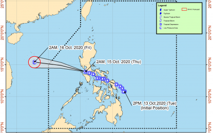
As of 3 p.m. Thursday, Ofel was tracked 340 kilometer west northwest of Tanauan City, Batangas, or 250 km. west of Subic, Zambales, moving west northwestward at 25 km per hour.
It packs a maximum sustained winds 45 kph near the center, and gustiness of up to 55 kph.
Ofel and the southwest monsoon are expected to bring scattered rain showers and thunderstorms over Metro Manila, Visayas, Calabarzon, Mimaropa, Bicol Region, Caraga, Northern Mindanao, Zamboanga Peninsula, and BARMM, likely until Friday.
The northeasterly surface windflow, on the other hand, will cause scattered rain showers over Cagayan Valley, Cordillera Administrative Region, and Central Luzon.
The rest of the country will have isolated rain showers due to localized thunderstorms.
Meanwhile, moderate to strong winds, moderate to rough coastal waters will prevail over Luzon.
Elsewhere, winds will be light to moderate with slight to moderate seas, PAGASA said.