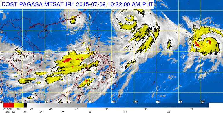
MANILA — Government has cautioned against sailing in the seas of Luzon and the Visayas until this weekend, expecting “rough to very rough” waters there from continuing onslaught of the enhanced southwest monsoon or “hanging habagat.”
“Such sea condition is possible up to Saturday (July 11) and Sunday (July 12),” said forecaster Robert Badrina from State weather agency Philippine Atmospheric, Geophysical and Astronomical Services Administration (PAGASA).
He noted typhoon “Falcon” (international name “Chan-Hom”) remains over the Pacific Ocean but continues enhancing the southwest monsoon so turbulence in Luzon and Visayas seas can be expected in forthcoming days.
According to PAGASA, “habagat” consists of warm moist winds from the southwest.
PAGASA said “habagat” causes rains over the country’s western portion from May to September.
In its gale warning issued Thursday morning (July 9), PAGASA warned of waves 3.
4 meters to 4.5 meters high in “rough to very rough” waters off Luzon’s northern and western seaboards covering Batanes, Ilocos, La Union, Pangasinan, Zambales, Bataan, Cavite, Mindoro Occidental,Palawan, northern Cagayan and western Batangas provinces, Calayan and Babuyan group of islands and Metro Manila.
PAGASA forecasts there monsoon rains and winds of 52 to 63kilometers per hour.
The agency also expects “rough to very rough” seas and waves 3.4 meters to 4.5 meters high in Luzon’s eastern and southern seaboards as well as the Visayas’ western and central seaboards.
People must avoid sailing in seas off Luzon’s Polillo and Burias islands and Isabela, Aurora, Quezon, Camarines, Catanduanes, Albay, Sorsogon, Mindoro Oriental, Marinduque, Romblon, Masbate, eastern Cagayan and southern Batangas provinces as well as the Visayas’ Negros Occidental, Guimaras, Iloilo, Capiz, Aklan, Antique, Bohol, Cebu,Negros Oriental, Samar and Leyte provinces, noted PAGASA.
“Fishing boats and other small seacraft are advised not to venture out into the sea while larger sea vessels are alerted against big waves,” PAGASA also said in the gale warning.
PAGASA based such forecast on expected occurrence of strong to gale-force winds associated with “habagat” that’s enhanced by typhoon “Falcon” and storm “Egay” (international name “Linfa”).
“Egay” exited the Philippine Area of Responsibility (PAR) earlier this week.
Badrina said “Falcon” is moving northwestwards, “pulling” part of the southwest monsoon towards this direction.
He noted PAGASA expects “Falcon” to exit PAR on Friday morning (July 10).
“Even if such happens, however, ‘Falcon’ will still enhance ‘habagat’ so rough to very rough seas in Luzon and the Visayas are still possible,” he said.
PAGASA’s 5 a.m. 24-hour public weather forecast released Thursday reported “Falcon” as packing maximum sustained winds of 130 kilometers per hour near its center and gustiness of up to 160 kph.
The agency located “Falcon” at 885 kilometers northeast of Batanes’ Itbayat municipality as of 4 a.m. of Thursday.
“Falcon” is forecast to move west-northwest at 20 kilometers per hour, added PAGASA.
