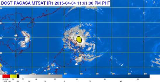
MANILA — Typhoon “Chedeng” has weakened into a tropical storm over the Philippine Sea while public storm warning signal no. 3 was raised over to the provinces of Isabela and Aurora, the Philippine Atmospheric, Geophysical and Astronomical Services Administration (PAGASA), said on Saturday.
PAGASA defines a tropical storm as moderate tropical cyclone with maximum wind speed of 64 to 118 kph (25 to 75 mph).
In an interview, PAGASA weather forecaster Aldczar Aurelio said that as of 5 p.m. Tropical storm Chedeng was located at 320 km Southeast of Casiguran, Aurora (15.07°N, 124.8.°E) packed with maximum sustained winds of 115 kph near the center and gustiness of up to 145 kph. It is forecast to move west northwest at 20 kph.
Aurelio said the tropical storm Chedeng, with maintaining its speed and movement, was expected to make landfall over the coast of Southern Isabela by Sunday morning (April 5), will exit the landmass via Ilocos Sur by Sunday afternoon (April 5) and will exit PAR by Monday morning (April 6).
The estimated rainfall amount is from moderate to heavy within the 150 km radius of the tropical storm while the sea surface waves of up to 6-8 meters near the center of the Storm.
Fisherfolk are advised not to venture out over the northern seaboard of Northern Luzon and eastern seaboard of Bicol Region and of Visayas.
PAGASA raised public storm warning signal No. 3 (winds of 101-185 kilometers per hour) over the provinces of Isabela and Aurora.
Residents in low-lying and mountainous areas are alerted against flashfloods and landslides.
PAGASA said that provinces of Northern Quezon, Nueva Ecija, Southern Cagayan, Kalinga, Mt. Province, Ifugao, Benguet, Nueva Viscaya, Quirino and Catanduanes are now under signal no. 2 (Winds of 61-100 kilometers per hour expected in at least 24 hours).
These areas will have stormy weather with heavy to intense rains. Residents in low-lying and mountainous areas are alerted against possible flash floods and landslides.
On the other hand, PSWS No. 1 (Winds of 30-60 kph expected in at least 36 hours) was hoisted over the rest of Cagayan including Babuyan Island, Apayao, Ilocos Norte, Ilocos Sur, Abra, La Union, Pangasinan, Tarlac, Pampanga, Bulacan, Rizal, Rest of Quezon, including Polillo Island, Camarines Norte and Camarines Sur.
These areas will have moderate to heavy rains with occasional gusty winds.
Residents in low lying and mountainous areas of the provinces with PSWS#3, PSWS#2 and PSWS#1 are alerted against possible flashfloods and landslides.
Aurelio said since the tropical storm moves near the Isabela and Aurora provinces, most part of Luzon including Metro Manila will experience cloudy skies with rainshowers and gusty winds on Sunday.
In its 24 hours forecast, PAGASA said the regions of Cagayan Valley, Cordillera, Ilocos and the provinces of Aurora, Quezon and Catanduanes will experience stormy weather with rough to very rough seas.
Metro Manila, the rest of Central Luzon, CALABARZON and Bicol Region and the provinces of Marinduque and Northern Samar will have cloudy skies with light to moderate rains and thunderstorms while the rest of the country will be partly cloudy to cloudy with isolated rainshowers or thunderstorms.
It added moderate to strong winds coming from the northeast to northwest will prevail over the rest of Luzon and Eastern Visayas with moderate to rough seas.
Elsewhere, winds will be light to moderate coming from the northeast to east with slight to moderate seas.
The state weather bureau issued gale warning due to the effects of typhoon Chedeng will bring rough to very rough sea conditions over the northern seaboard of Luzon and the eastern seaboard of Bicol Region.
Fisherfolks and those using small seacraft are advised not to venture out over the said seaboards, it warned.
