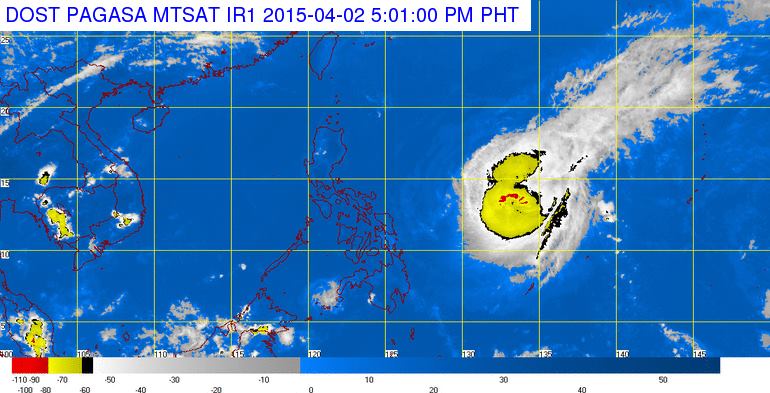
MANILA — Typhoon “Chedeng” has slowed down but maintained its strength while continuing its movement in a northwest direction that is not yet expected to affect any part of the country in the next 24 hours, according to the Philippine Atmospheric, Geophysical and Astronomical Services Administration (PAGASA) on Thursday afternoon.
In an interview, PAGASA weather forecaster Jun Galang said that as of 5 p.m., the typhoon was located based on all available data at 960 kilometers east of Virac, Catanduanes (13.1°N, 133.1°E) packed with maximum sustained winds of 175 kilometers per hour near the center and gustiness of up to 210 kph. It is forecast to move northwest at a decelerated speed of 15 kph from 19 kph earlier Thursday morning.
Based on its present speed and movement, Galang said the typhoon is expected to make landfall over the eastern coast of Aurora or Isabela by Easter Sunday (April 5).
The public is alerted against possible flashfloods in low-lying areas and landslides along mountain slopes, particularly over Aurora-Isabela area.
According to Galang, the state weather bureau will raise Public Storm Warning Signal No. 1 within the next 12 hours over Bicol provinces. Hence, sea travel over these areas will be possibly suspended.
The estimated rainfall amount is from moderate to heavy within the 150- to 200-km radius of the typhoon.
Storm surges and sea surface waves of up to four meters are possible over the eastern coast of Samar, Bicol and Aurora-Quezon. Fisherfolks are advised not to venture out over the eastern seaboard of Bicol Region and of Visayas.
Galang said that so far, Chedeng is still not affecting the country which continues to experience generally fair weather until Good Friday.
He added that once the typhoon moves closer to the landmass, it will bring rains in most parts of Luzon, including Metro Manila, by weekend.
In the next 24-hour weather forecast, PAGASA said the regions of Cagayan Valley, Cordillera and Ilocos will experience partly cloudy skies. Metro Manila and the rest of the country will be partly cloudy to cloudy with isolated rainshowers or thunderstorms.
It added that moderate to strong winds coming from the northeast to northwest will prevail over the eastern sections of Central and Southern Luzon, of the Visayas and Mindanao with moderate to rough seas.
Elsewhere, winds will be light to moderate coming from the east to northeast with slight to moderate seas.
Meanwhile, the state weather bureau issued a gale warning due to the effects of typhoon Chedeng which will bring rough to very rough sea conditions over the eastern seaboard of Central and Southern Luzon and the eastern seaboard of the Visayas.
“Fisherfolks and those using small seacraft are advised not to venture out over the said seaboards,” it warned.
