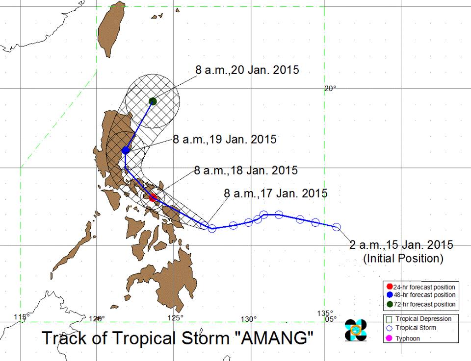
MANILA — Public storm warning signal (PSWS) No. 2 has been raised over eight areas in Luzon and the Visayas as tropical storm “Amang” intensified further and continued to threaten the Samar provinces in Eastern Visayas, according to the Philippine Atmospheric, Geophysical and Astronomical Services Administration (PAGASA) on Saturday.
In an interview, PAGASA weather forecaster Alvin Pura said Eastern Visayas and the Bicol region will be stormy with rough to very rough seas.
Under PSWS No. 2 (61-100 kilometer per hour winds expected in at least 24 hours) are Sorsogon, Masbate, Ticao Island, Northern Samar, Eastern Samar, Samar, Leyte and Biliran
The potential impacts of the winds under signal No. 2 are the following:
• Moderate damage to agriculture
• Rice and corn plants adversely affected
• Few large trees uprooted
• Large number of nipa and cogon houses partially or totally unroofed
• Some old galvanized iron roofing may roll off
• Travel by all types of sea vessels is risky.
Meanwhile, Signal No. 1 (30-60 kph winds expected in at least 36 hours) is hoisted over Catanduanes, Albay, Camarines Sur, Camarines Norte, Burias Island, Quezon, Polillo Island, Laguna, Batangas, Marinduque, Oriental Mindoro, Romblon, Southern Leyte, Northern Cebu, Cebu CityCamotes Island, Capiz, Aklan and Dinagat Island.
PAGASA warned residents in low-lying and mountainous areas of the provinces with PSWS#2 and #1 against possible flashfloods and landslides.
The estimated rainfall amount is from 7.5 to 20 millimeters per hour (heavy to intense) within the 400-km diameter of the tropical storm.
Ocean waves may reach up to nine meters within the diameter of the storm.
Fisherfolks and those with small seacrafts are advised not to venture out over the seaboards of Luzon, the Visayas and the eastern seaboard of Mindanao.
Pura said that as of 4 a.m. Saturday, tropical storm Amang was located at 220 km east-southeast of Borongan City, Eastern Samar (10.9°N, 127.3°E).
Pura said the storm has increased its maximum sustained winds from 75 kph to 100 kph while its gustiness also rose from 90 kph to 130 kph.
It is forecast to move westward and accelerate from 15 kph to 17 kph.
With its present speed and movement, Pura said tropical storm “Amang” may hit Borongan City, Eastern Samar Saturday afternoon.
In the next six hours, there is a possibility of raising PSWS #1 over Cavite, Rizal, the National Capital Region (NCR) and Bulacan.
In its Saturday forecast, PAGASA said Central Visayas, Calabarzon (Cavite, Laguna, Batangas, Rizal and Quezon) and the provinces of Mindoro, Marinduque, Romblon and Dinagat will have rains with gusty winds with moderate to rough seas.
The rest of Mindanao and Palawan will experience cloudy skies with light to moderate rains. Thunderstorms are likely to occur over these areas.
Metro Manila and the rest of Luzon will have cloudy skies with light rains.
PAGASA said moderate to strong winds blowing from the northeast to northwest will prevail over the rest of the country with moderate to rough seas.
The state weather bureau issued gale warning due to the combined effects of tropical storm “Amang” and the northeast monsoon which will bring rough to very rough sea conditions over the seaboards of Northern and Central Luzon, the western seaboard of Southern Luzon, the western and central seaboards of Visayas and the eastern seaboard of Mindanao.
Fisherfolks and those using small seacraft are advised not to venture out over the said seaboards,” it warned.
