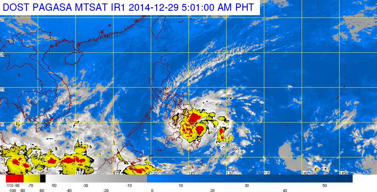
MANILA — Public storm warning signal (PSWS) no. 2 has been raised in nine areas in Visayas and Mindanao as Tropical Depression “Seniang” has intensified into a Tropical Storm, according to the Philippine Atmospheric Geophysical and Astronomical Services Administration (PAGASA) on Monday.
PAGASA defines a tropical storm as moderate tropical cyclone with maximum wind speed of 64 to 118 kph (25 to 75 mph).
Areas under Storm Signal No. 2 (Winds of 61-100 kilometers per hour expected in at least 24 hours) are Bohol and Siquijor in Visayas; Surigao del Sur, Surigao del Norte, Siargao Island, Agusan del Norte, Agusan del Sur,Misamis Oriental and Camiguin in Mindanao.
These areas will have stormy weather with heavy to intense rains. Residents in low lying and mountainous areas are alerted against possible flashfloods and landslides.
On the other hand, Public storm warning Signal No. 1 (Winds of 30-60 kph is expected in at least 36 hours) is hoisted over Leyte, Southern Leyte, Camotes Island, Cebu, Negros Oriental and Negros Occidental in Visayas; Dinagat Province, Compostela Valley, northern part of Davao Oriental, Davao del Norte, Bukidnon, Lanao del Norte, Misamis Occidental and Zamboanga del Norte in Mindanao.
These areas will have moderate to heavy rains with occasional gusty winds. Residents in low lying and mountainous areas are alerted against possible flashfloods and landslides.
In an interview, PAGASA weather forecaster Denison Estareja said that as of 6 a.m., the center of Tropical Storm “Seniang” was estimated based on all available data at 45 km of Hinatuan, Surigao del Sur (8.7°N, 126.1°E) packed with maximum sustained winds of 65 kph near the center and gustiness of up to 80 kph. It was forecast to move West Northwest at 11 kph.
Estareja said TS “Seniang” has made landfall over Bakulin, Hinatuan, Surigao del Sur around 3:45 a.m. Monday and will exit the landmass of Agusan del Norte by noon then will traverse Bohol sea.
He said “Seniang” maintains its movement and speed and is expected to make another landfall in Camguin around 6-8 p.m. Monday, then another landfall in Bohol around 12-2 a.m. by Tuesday. It is also expected to make another landfall in Southern Cebu, Negros Oriental and Southern Palawan.
The weather forecaster said “Seniang” is expected to exit Philippine Area of Responsibility (PAR) on January 1 (Thursday) around 6-8 p.m. heading towards southern Vietnam.
He noted the tropical storm will not affect some parts of Luzon due to the strong presence of northeast monsoon.
However, due to the effects of tropical storm “Seniang” and the Northeast Monsoon, sea conditions over the eastern seaboard of Luzon and of Visayas will be rough to very rough, he said.
Fisherfolks and those using small sea craft are advised not to venture out over the said seaboards, it warned.
For Monday forecast, PAGASA said that Caraga and the Provinces of Misamis Oriental, Camiguin, Bohol and Siquijor will experience stormy weather while the rest of Northern Mindanao, Central Visayas, Davao Region and the Provinces of Negros, Leyte and Zamboanga del Norte will have rains with gusty winds.
The coastal waters along these areas will be rough to very rough.
Bicol Region and the rest of Visayas and of Mindanao will experience cloudy skies with light to moderate rainshowers and thunderstorms while Cagayan Valley, Cordillera, Ilocos Region and Central Luzon will have cloudy skies with light rains.
Metro Manila and the rest of Luzon will be partly cloudy to at times cloudy with isolated light rains.
Moderate to strong winds blowing from the northeast will prevail over Luzon while the rest of Visayas and of Mindanao will have moderate to rough seas.
