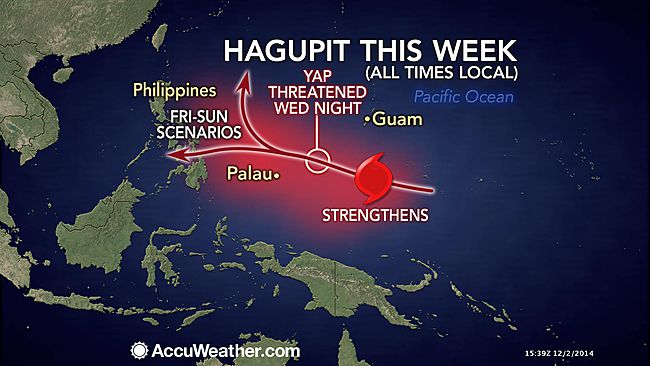
MANILA – The Philippine Atmospheric, Geophysical and Astronomical Services Administration (PAGASA) said on Wednesday that typhoon “Hagupit” will enter the country on Thursday with a high chance of making a landfall in Eastern Visayas.
PAGASA weather forecaster Manny Mendoza said once the typhoon enter the country, it would be called “Ruby”, the 18th tropical cyclone to affect the country this year.
As of 4 p.m., typhoon Hagupit was located, based on all available data, at 1,278 km East of Hinatuan, Surigao Del Sur (8.5ºN, 137.9ºE) packed with maximum sustained winds of 160 kph near the center and gustiness of up to 195 kph. It is forecast to move West Northwest at 30 kph.
Mendoza said on Friday this will be the critical day for the weather forecaster to know the track of typhoon “Ruby” whether it will make landfall or will re-curve.
According to Mendoza, typhoon Ruby is moving towards Eastern Visyas and if it maintain its speed of 30 kph, it has 60 percent chance of making a landfall in Eastern Samar in the early evening of Saturday.
He said the other scenario — if typhoon Ruby is affected by the frontal system, it will re-curve and moves towards Japan.
”Critical ang araw ng Biyernes pinagaaralan naming ng husto kung saan tutungo ito Bagyong Ruby kung may frontal system sa Hilagang parte ng bagyo at sumama sa bagyong ito ay magkakaroon ng recurve lilihis ng landmass going to northwest then going to north patungong southern island ng Japan kya critical ang araw ng Friday,” he said.
He also said that if the typhoon move slower or in stationary, it is also expected to make a re-curve.
In another interview, PAGASA weather forecaster Aldczar Aurelio said typhoon Ruby will not be as strong as typhoon “Yolanda.”
He said typhoon Ruby will also bring strong winds but not as strong as the winds brought by Yolanda, the super typhoon that devastated Eastern Visayas in November 2013.
He said that whether Ruby will make landfall or not, it will dump moderate to heavy rains in Eastern Visayas, which will lead to possible flash floods in low-lying areas and landslides in mountainous areas.
He also said if Ruby will make a landfall, a stormy weather is expected mostly in Visayas while the seaboard of Visayas and Southern Luzon will also be rough to very rough due to typhoon.
Aurelio said if the typhoon will re-curve, it will bring moderate to occasional rainshowers over Eastern Visayas and Bicol Region.
In the next 24 hours, PAGASA said Northeast monsoon continues to affect Northern and Central Luzon.
In its 5 p.m. forecast, PAGASA said Eastern Visayas will experience cloudy skies with light to moderate rainshowers and thunderstorms. Cagayan Valley will have cloudy skies with light rains while the regions of Cordillera, Ilocos, and Central Luzon will experience partly cloudy to at times cloudy skies with isolated light rains.
It added that Metro Manila and the rest of the country will be partly cloudy to cloudy with isolated rainshowers or thunderstorms.
The weather bureau also said that moderate to strong winds blowing from the Northeast to East will prevail over Luzon and the Eastern section of Visayas and the coastal waters along these areas will be moderate to rough.
Elsewhere, winds will be light to moderate coming from the Northeast with slight to moderate seas.