Canada News
All eyes on Ernesto as storm tracks north toward Atlantic Canada
By Ryan Snoddon, CBC News, RCI
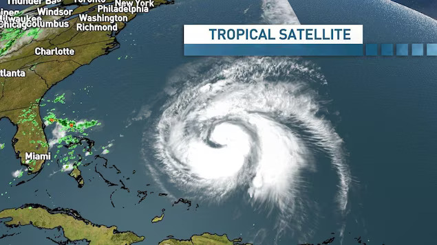
Hurricane Ernesto will track near Bermuda this weekend and looks set to impact the island with Category 2- or 3-strength winds, heavy rain and pounding waves, before continuing north into Atlantic Canadian waters. Photo: CBC / Ryan Snoddon
Ernesto is expected to stay offshore, but could still bring heavy rain to the Maritimes on Monday
After tracking through the Caribbean with damaging winds and torrential rain, Hurricane Ernesto is now moving north.
The hurricane will track near Bermuda (new window) and looks set to impact the island with Category 2- or 3-strength winds, heavy rain and pounding waves this weekend.
Beyond that, the storm will continue to move north into Atlantic Canadian waters late Sunday and through Monday.
Ernesto will track well south of Nova Scotia with the centre of the storm now looking likely to be southeast of Sable Island.
However, the storm will be rather large as it moves through the region and some outer bands of rain and downpours may still track into the Maritimes on Monday.
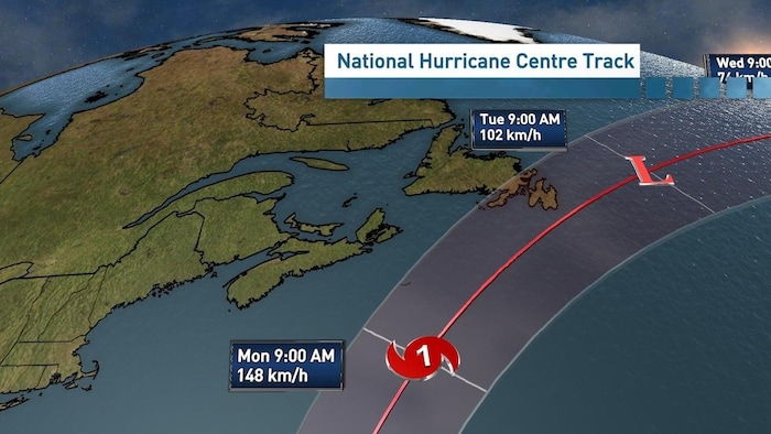
The latest National Hurricane Centre Track shows Ernesto moving into Atlantic Canadian waters, before shifting southeast of Nova Scotia and toward Newfoundland.
Photo: CBC / Ryan Snoddon
Nova Scotia would be at the greatest risk of seeing this rain, however, southern New Brunswick and Prince Edward Island may also see some rain depending on the track.
The strongest winds will remain offshore, with the potential for any wind impacts looking low for the Maritimes.
What the Maritimes will see is pounding surf along the Atlantic coastline beginning Sunday and continuing into Tuesday. Anyone at the beach should be extremely cautious of the high waves and a greater potential for riptides.
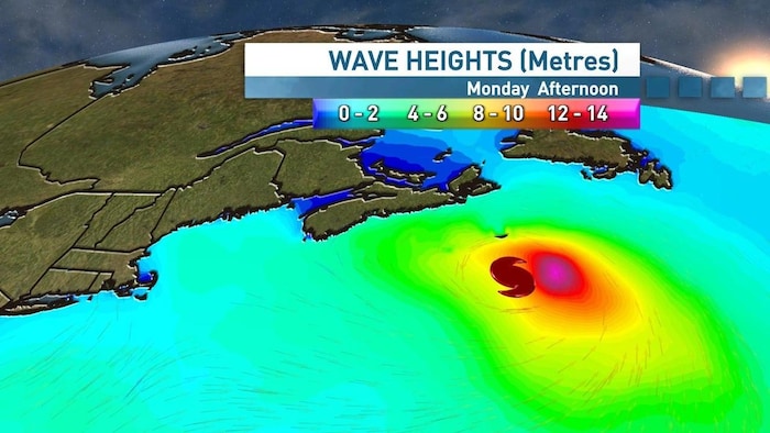
This map shows wave heights in metres that Hurricane Ernesto may bring to Atlantic Canada.
Photo: CBC / Ryan Snoddon
Newfoundland impacts
Newfoundland is looking more likely to see direct impacts from Ernesto.
While the centre of the storm may remain offshore, there’s a higher possibility of both rain and wind impacting southeastern Newfoundland, including the Avalon Peninsula. There’s also the potential for storm surge to impact southeastern areas of the island.
Based on the latest projections, Newfoundland would be more likely to see impacts Monday and into early Tuesday.
A tropical cyclone information statement is in place for eastern Newfoundland.
Watching the jet stream
A trough in the jet stream moving out of the Great Lakes this weekend will be key in the eventual track of Ernesto.
As the strong upper-level winds in the jet stream move into Atlantic Canada, they will heavily influence Ernesto and its turn to the northeast.
As the timing of that trough begins to firm up, we’ll get even greater detail on the track of Ernesto and its impacts in Atlantic Canada
WATCH | Ernesto’s impact in Puerto Rico:
Offshore sector should take note
The Canadian Hurricane Centre said warm ocean temperatures are playing a role in intensifying the storm near Bermuda.
However, Chris Fogarty, a meteorologist with the centre, said that’s less of an issue in the North Atlantic, as water temperatures near the coast of Nova Scotia are cooler than usual this year.
It’s going to generate huge waves and that will be quite challenging, not just for the onshore regions [of Atlantic provinces], but also for the offshore sector,
he said.
The centre said offshore oil facilities should certainly pay attention to this storm.