Connect with us

News

Satellites zoom in on cities’ hottest neighborhoods to help combat the urban heat island effect

Published

on

Electric fan in a sun-lit room

With rising global temperatures increasing the likelihood of dangerous heat waves, cities need to know which neighborhoods are at high risk. Excessive heat can lead to dehydration, heat exhaustion, heat stroke and even death with prolonged exposure, and the most at-risk residents often lack financial resources to adapt. (File Photo: Marius Matuschzik/Unsplash)

Spend time in a city in summer and you can feel the urban heat rising from the pavement and radiating from buildings. Cities are generally hotter than surrounding rural areas, but even within cities, some residential neighborhoods get dangerously warmer than others just a few miles away.

Within these “micro-urban heat islands,” communities can experience heat wave conditions well before officials declare a heat emergency.

I use Earth-observing satellites and population data to map these hot spots, often on projects with NASA. Satellites like the Landsat program have become crucial for pinpointing urban risks so cities can prepare for and respond to extreme heat, a top weather-related killer.

Among the many things we’ve been able to track with increasingly detailed satellite data is that the hottest neighborhoods are typically low-income and often have predominantly Black or Hispanic residents.

Two types of urban heat, both dangerous

The urban heat island effect was first described in 1818, over 200 years ago, in “The Climate of London” by Luke Howard, an early pioneer of meteorology.

There are two distinct types of urban heat island: the atmospheric urban heat island and the surface urban heat island. They are measured in different ways.

Two maps of the same area of Indianapolis, one showing the satellite view of pavement, buildings and greenery and the other showing the surface temperature differences, which range from 68.6 over water to 118.6
The image on the right shows the surface urban heat island of Indianapolis in July 2019. Note the higher-density built areas in red are much warmer than the cooler, more vegetated areas in blue.
NASA/USGS Landsat

The atmospheric urban heat island, the phenomenon described by Howard, is simply the warmer air in urban areas relative to cooler air in outlying locations.

The surface urban heat island is the result of surfaces made up of heat-absorbing materials, such as asphalt, concrete and metal. Such materials are highly effective absorbers of heat energy from the Sun, and their surfaces warm rapidly and in turn emit the absorbed energy. You can feel the heat when you touch them.

The surface urban heat island directly contributes to the atmospheric urban heat island and is usually most intense on sunny days. Urbanization also contributes to the heat island effect through deforestation and the removal of other vegetation that would provide some cooling.

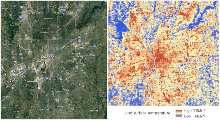
Where communities faces the highest heat

With rising global temperatures increasing the likelihood of dangerous heat waves, cities need to know which neighborhoods are at high risk. Excessive heat can lead to dehydration, heat exhaustion, heat stroke and even death with prolonged exposure, and the most at-risk residents often lack financial resources to adapt.

Map of Chicago showing how heat deaths clustered in the urban core during the 1995 heat wave.
The July 1995 Chicago heat wave was blamed for over 739 deaths in a five-day period. Most victims were poor and elderly people who lacked air conditioning or feared opening windows because of crime. This figure shows the location of heat-related deaths clustered in areas of higher surface urban heat intensity.
Daniel P. Johnson, CC BY-ND

Satellite instruments can identify communities vulnerable to extreme heat because they can measure and map the surface urban heat island in high detail.

For example, industrial and commercial zones are frequently among the hottest areas in cities. They typically have fewer trees to cool the air and more pavement and buildings to retain and radiate heat.

Certain residential layouts are also more prone to higher surface temperatures than others. These neighborhoods usually have minimal vegetation, and homes are built close together, with more roads and sidewalks and little green space. Often, especially in northern climates, homes in these neighborhoods were built with materials such as brick that retain heat to keep occupants warmer in the winter. Communities with many apartment buildings and stores surrounded by parking lots are also at high risk.

Two maps of New York City show how vegetation matches cooler areas by temperature.
Comparing maps of New York City’s vegetation and temperature shows the cooling effect of parks and neighborhoods with more trees.
NASA/USGS Landsat

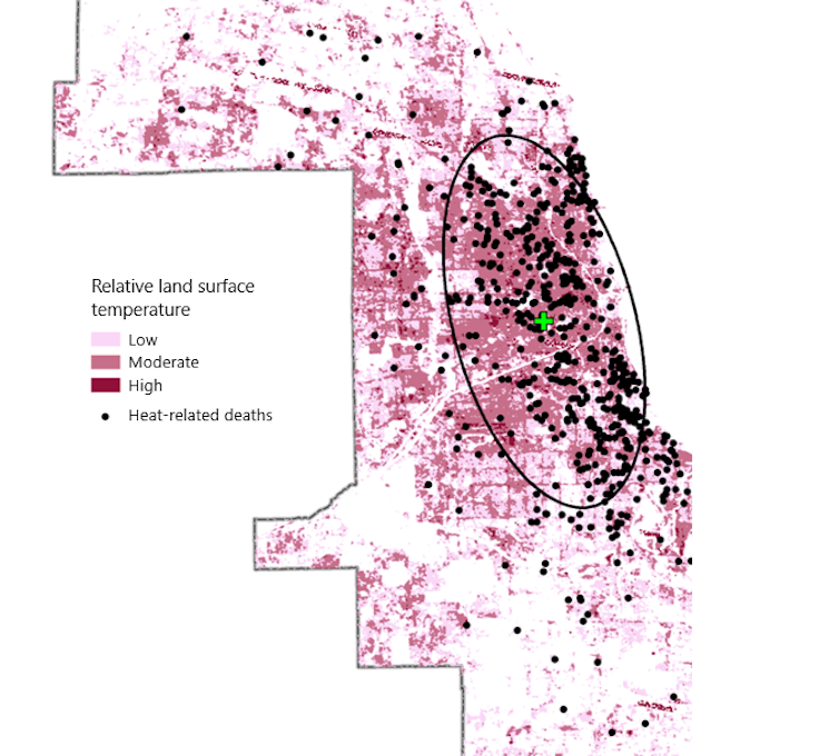
My research has found that on warm summer days, low-income communities of color can experience extreme heat conditions that are often more than 10 degrees Fahrenheit (5.5 C) warmer than surrounding areas. Other research has found similar differences among neighborhoods and stark racial and economic disparities when it comes to heat exposure.

One recent study found that the poorest areas were significantly hotter than the richest in 76% of urban U.S. counties. It also found that neighborhoods with large Black, Hispanic and Asian populations were in significantly hotter areas in 71% of counties, and that that difference remained even when adjusting for income. These areas tend to have less vegetation and a higher density of homes.

Another study looked at communities that had once been redlined, a discriminatory practice banks used in the early to mid-20th century to deny loans in racial and ethnic minority communities. Nationally, these formerly redlined neighborhoods were 4.6 F (2.6 C) warmer than nonredlined areas.

50 years of Landsat

Several satellite systems can now measure the surface urban heat island, but the Landsat program, which celebrates its 50th anniversary in 2022, provides decades of continuous, comparable data in the detail necessary to examine variations within a city. That continuity helps scientists measure the impact of changes and track how development patterns change a neighborhood’s heat profile.

The first Landsat satellite was launched on July 23, 1972, with a sensor that collected data in green, red and near-infrared wavelengths that made it useful for mapping vegetation. Beginning with Landsat 4, launched in July 1982, scientists could map and measure thermal characteristics of Earth’s surface. Today, Landsat 8 and Landsat 9 are operating, and a 10th is being developed.

How cities can use this data to help

There are numerous ways cities can use this data to help residents combat extreme heat.

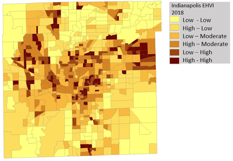
In Indianapolis, local government and faith-based organizations have used extreme heat vulnerability indices, which use indicators of heat-health risk and past heat waves to highlight high-risk communities. Knowing which communities are likely to be at the highest risk allows them to guide outreach to the most vulnerable people both before and during periods of elevated temperatures.

New York’s “Cool Neighborhoods NYC” program includes strategically planting trees and vegetation to increase shade and evapotranspiration, which cools the surrounding area. It also discusses painting roofs and pavement light colors to reflect solar energy and educating at-risk communities about heat risk and ways they can get help.

Map of Indianapolis showing how risk is pinpointed by a heat vulnerability index created by the author.
An extreme heat vulnerability index highlights areas that are more likely to experience heat-related illnesses and deaths. Darker browns indicate elevated risk. This index uses Landsat data to measure differences in surface temperature throughout the city, with socioeconomic indicators painting a highly accurate picture of community-level extreme heat health risk.
Daniel P. Johnson, CC BY-ND

As the climate continues to warm and affect urban health, the Landsat satellites’ sensors are among our best tools for monitoring the thermal variations of the urban heat island. Such work also serves as one of the best examples of employing satellite-based measurements to monitor and implement response to public health threats.The Conversation

Daniel P. Johnson, Associate Professor of Geography, IUPUI

This article is republished from The Conversation under a Creative Commons license. Read the original article.

xosotin chelseathông tin chuyển nhượngcâu lạc bộ bóng đá arsenalbóng đá atalantabundesligacầu thủ haalandUEFAevertonxosofutebol ao vivofutemaxmulticanaisonbethttps://bsport.fithttps://onbet88.ooohttps://i9bet.bizhttps://hi88.ooohttps://okvip.athttps://f8bet.athttps://fb88.cashhttps://vn88.cashhttps://shbet.atbóng đá world cupbóng đá inter milantin juventusbenzemala ligaclb leicester cityMUman citymessi lionelsalahnapolineymarpsgronaldoserie atottenhamvalenciaAS ROMALeverkusenac milanmbappenapolinewcastleaston villaliverpoolfa cupreal madridpremier leagueAjaxbao bong da247EPLbarcelonabournemouthaff cupasean footballbên lề sân cỏbáo bóng đá mớibóng đá cúp thế giớitin bóng đá ViệtUEFAbáo bóng đá việt namHuyền thoại bóng đágiải ngoại hạng anhSeagametap chi bong da the gioitin bong da lutrận đấu hôm nayviệt nam bóng đátin nong bong daBóng đá nữthể thao 7m24h bóng đábóng đá hôm naythe thao ngoai hang anhtin nhanh bóng đáphòng thay đồ bóng đábóng đá phủikèo nhà cái onbetbóng đá lu 2thông tin phòng thay đồthe thao vuaapp đánh lô đềdudoanxosoxổ số giải đặc biệthôm nay xổ sốkèo đẹp hôm nayketquaxosokq xskqxsmnsoi cầu ba miềnsoi cau thong kesxkt hôm naythế giới xổ sốxổ số 24hxo.soxoso3mienxo so ba mienxoso dac bietxosodientoanxổ số dự đoánvé số chiều xổxoso ket quaxosokienthietxoso kq hôm nayxoso ktxổ số megaxổ số mới nhất hôm nayxoso truc tiepxoso ViệtSX3MIENxs dự đoánxs mien bac hom nayxs miên namxsmientrungxsmn thu 7con số may mắn hôm nayKQXS 3 miền Bắc Trung Nam Nhanhdự đoán xổ số 3 miềndò vé sốdu doan xo so hom nayket qua xo xoket qua xo so.vntrúng thưởng xo sokq xoso trực tiếpket qua xskqxs 247số miền nams0x0 mienbacxosobamien hôm naysố đẹp hôm naysố đẹp trực tuyếnnuôi số đẹpxo so hom quaxoso ketquaxstruc tiep hom nayxổ số kiến thiết trực tiếpxổ số kq hôm nayso xo kq trực tuyenkết quả xổ số miền bắc trực tiếpxo so miền namxổ số miền nam trực tiếptrực tiếp xổ số hôm nayket wa xsKQ XOSOxoso onlinexo so truc tiep hom nayxsttso mien bac trong ngàyKQXS3Msố so mien bacdu doan xo so onlinedu doan cau loxổ số kenokqxs vnKQXOSOKQXS hôm naytrực tiếp kết quả xổ số ba miềncap lo dep nhat hom naysoi cầu chuẩn hôm nayso ket qua xo soXem kết quả xổ số nhanh nhấtSX3MIENXSMB chủ nhậtKQXSMNkết quả mở giải trực tuyếnGiờ vàng chốt số OnlineĐánh Đề Con Gìdò số miền namdò vé số hôm nayso mo so debach thủ lô đẹp nhất hôm naycầu đề hôm naykết quả xổ số kiến thiết toàn quốccau dep 88xsmb rong bach kimket qua xs 2023dự đoán xổ số hàng ngàyBạch thủ đề miền BắcSoi Cầu MB thần tàisoi cau vip 247soi cầu tốtsoi cầu miễn phísoi cau mb vipxsmb hom nayxs vietlottxsmn hôm naycầu lô đẹpthống kê lô kép xổ số miền Bắcquay thử xsmnxổ số thần tàiQuay thử XSMTxổ số chiều nayxo so mien nam hom nayweb đánh lô đề trực tuyến uy tínKQXS hôm nayxsmb ngày hôm nayXSMT chủ nhậtxổ số Power 6/55KQXS A trúng roycao thủ chốt sốbảng xổ số đặc biệtsoi cầu 247 vipsoi cầu wap 666Soi cầu miễn phí 888 VIPSoi Cau Chuan MBđộc thủ desố miền bắcthần tài cho sốKết quả xổ số thần tàiXem trực tiếp xổ sốXIN SỐ THẦN TÀI THỔ ĐỊACầu lô số đẹplô đẹp vip 24hsoi cầu miễn phí 888xổ số kiến thiết chiều nayXSMN thứ 7 hàng tuầnKết quả Xổ số Hồ Chí Minhnhà cái xổ số Việt NamXổ Số Đại PhátXổ số mới nhất Hôm Nayso xo mb hom nayxxmb88quay thu mbXo so Minh ChinhXS Minh Ngọc trực tiếp hôm nayXSMN 88XSTDxs than taixổ số UY TIN NHẤTxs vietlott 88SOI CẦU SIÊU CHUẨNSoiCauVietlô đẹp hôm nay vipket qua so xo hom naykqxsmb 30 ngàydự đoán xổ số 3 miềnSoi cầu 3 càng chuẩn xácbạch thủ lônuoi lo chuanbắt lô chuẩn theo ngàykq xo-solô 3 càngnuôi lô đề siêu vipcầu Lô Xiên XSMBđề về bao nhiêuSoi cầu x3xổ số kiến thiết ngày hôm nayquay thử xsmttruc tiep kết quả sxmntrực tiếp miền bắckết quả xổ số chấm vnbảng xs đặc biệt năm 2023soi cau xsmbxổ số hà nội hôm naysxmtxsmt hôm nayxs truc tiep mbketqua xo so onlinekqxs onlinexo số hôm nayXS3MTin xs hôm nayxsmn thu2XSMN hom nayxổ số miền bắc trực tiếp hôm naySO XOxsmbsxmn hôm nay188betlink188 xo sosoi cầu vip 88lô tô việtsoi lô việtXS247xs ba miềnchốt lô đẹp nhất hôm naychốt số xsmbCHƠI LÔ TÔsoi cau mn hom naychốt lô chuẩndu doan sxmtdự đoán xổ số onlinerồng bạch kim chốt 3 càng miễn phí hôm naythống kê lô gan miền bắcdàn đề lôCầu Kèo Đặc Biệtchốt cầu may mắnkết quả xổ số miền bắc hômSoi cầu vàng 777thẻ bài onlinedu doan mn 888soi cầu miền nam vipsoi cầu mt vipdàn de hôm nay7 cao thủ chốt sốsoi cau mien phi 7777 cao thủ chốt số nức tiếng3 càng miền bắcrồng bạch kim 777dàn de bất bạion newsddxsmn188betw88w88789bettf88sin88suvipsunwintf88five8812betsv88vn88Top 10 nhà cái uy tínsky88iwinlucky88nhacaisin88oxbetm88vn88w88789betiwinf8betrio66rio66lucky88oxbetvn88188bet789betMay-88five88one88sin88bk88xbetoxbetMU88188BETSV88RIO66ONBET88188betM88M88SV88Jun-68Jun-88one88iwinv9betw388OXBETw388w388onbetonbetonbetonbet88onbet88onbet88onbet88onbetonbetonbetonbetqh88mu88Nhà cái uy tínpog79vp777vp777vipbetvipbetuk88uk88typhu88typhu88tk88tk88sm66sm66me88me888live8live8livesm66me88win798livesm66me88win79pog79pog79vp777vp777uk88uk88tk88tk88luck8luck8kingbet86kingbet86k188k188hr99hr99123b8xbetvnvipbetsv66zbettaisunwin-vntyphu88vn138vwinvwinvi68ee881xbetrio66zbetvn138i9betvipfi88clubcf68onbet88ee88typhu88onbetonbetkhuyenmai12bet-moblie12betmoblietaimienphi247vi68clupcf68clupvipbeti9betqh88onb123onbefsoi cầunổ hũbắn cáđá gàđá gàgame bàicasinosoi cầuxóc đĩagame bàigiải mã giấc mơbầu cuaslot gamecasinonổ hủdàn đềBắn cácasinodàn đềnổ hũtài xỉuslot gamecasinobắn cáđá gàgame bàithể thaogame bàisoi cầukqsssoi cầucờ tướngbắn cágame bàixóc đĩaAG百家乐AG百家乐AG真人AG真人爱游戏华体会华体会im体育kok体育开云体育开云体育开云体育乐鱼体育乐鱼体育欧宝体育ob体育亚博体育亚博体育亚博体育亚博体育亚博体育亚博体育开云体育开云体育棋牌棋牌沙巴体育买球平台新葡京娱乐开云体育mu88qh88
Continue Reading
Click to comment

Leave a Reply

Your email address will not be published. Required fields are marked *