Headline
Uwan further weakens over West Philippine Sea
By Ma. Teresa Montemayor, Philippine News Agency
(DOST-PAGASA/facebook)
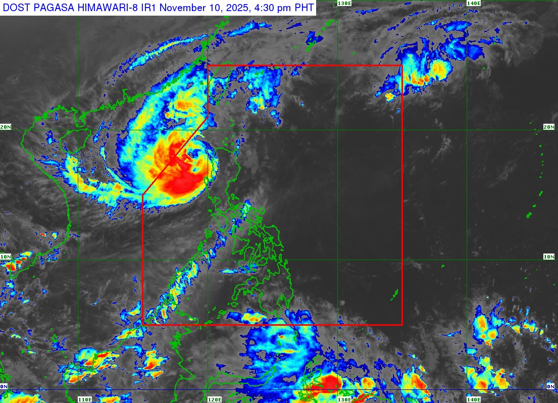
MANILA – Typhoon Uwan continued to weaken as it moved farther away from Luzon and into the West Philippine Sea on Monday morning, the Philippine Atmospheric, Geophysical and Astronomical Services Administration (PAGASA) said.
In its 11 a.m. bulletin, the weather bureau reported that the center of Uwan was estimated at 135 km west northwest of Bacnotan, La Union, carrying maximum sustained winds of 130 kilometers per hour (km/h) near the center, gustiness of up to 160 km/h, and a central pressure of 970 hectopascal (hPa), moving west northwestward at 20 km/h.
Uwan’s circulation continues to weaken following its interaction with the rugged terrain of Northern Luzon and the Sierra Madre mountain range on Sunday.
Despite this, strong to typhoon-force winds still extend outward up to 850 km from the center.
Signal No. 3 remains raised over Ilocos Sur, northern and central La Union, and the northwestern portion of Pangasinan, where storm-force winds may cause moderate to significant damage to structures and vegetation.
Areas under Signal No. 2 include Batanes, Cagayan, Isabela, Quirino, Nueva Vizcaya, Apayao, Abra, Kalinga, Mountain Province, Ifugao, Benguet, Ilocos Norte, the rest of La Union, Pangasinan, Aurora, Zambales, Bataan, Nueva Ecija, Tarlac, Pampanga, and Bulacan.
Signal No. 1 is still up over Metro Manila, parts of Southern Luzon, and portions of the Visayas, including Aklan, Capiz, and northern Antique.
PAGASA warned of life-threatening storm surges exceeding three meters along the coastal areas of Ilocos Region, Cagayan Valley, Central Luzon, Metro Manila, Calabarzon, Mimaropa, Aklan, and Antique within the next 12 hours.
A gale warning is also in effect over the seaboards of northern and central Luzon, and the western seaboard of southern Luzon, with sea heights reaching up to eight meters in some areas.
Sea travel remains risky for all types of vessels, especially small boats and motorbancas.
Strong to gale-force winds may still be experienced over Palawan, the Visayas, the Zamboanga Peninsula, Northern Mindanao, Dinagat Islands, Soccsksargen, and parts of the Davao Region.
Uwan is forecast to continue moving west-northwestward on Monday before turning northward over the West Philippine Sea on Tuesday.
It may briefly re-intensify as it moves over open waters, then weaken again as it heads toward the Taiwan Strait midweek.
It may re-enter PAR on Wednesday evening as it makes landfall over the southwestern coast of Taiwan, resulting in further weakening.
It will then emerge over the waters near the Ryukyu Islands on Thursday, where it is expected to eventually weaken into a remnant low on Friday.