Headline
Potential super typhoon Uwan approaches Philippines; 21 areas now under Signal No. 1
By Nash Villena, Philippine Canadian Inquirer
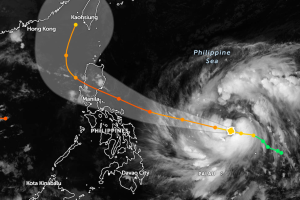
TROPICAL STORM UWAN. The forecast track of tropical storm Uwan (Fung-Wong) as it approaches the Philippines on Friday evening (Nov. 7, 2025). (Screengrab from Zoom Earth)
MANILA, Philippines — The severe tropical storm following Typhoon Tino is expected to enter the Philippine Area of Responsibility (PAR) in the next several hours, PAGASA reported on Friday, November 7.
As of 5 PM, the weather bureau last located the tropical storm with the international name “Fung-wong” 1,175 kilometers east of Eastern Visayas and tracked its movement westward with a consistent speed of 25 kph.
It was also recorded to have maximum sustained winds of 110 kph and gustiness of up to 135 kph.
Projected to enter the PAR by late evening Friday or early morning Saturday, the storm upon its entrance shall be officially called by its local name “Uwan.”
PAGASA has recently released a tropical cyclone bulletin raising wind signals over 21 areas in the country.
The following affected areas, where the Signal No. 1 was hoisted as of 5 PM on Friday, are as follows:
- The southeastern portion of Quezon (Tagkawayan, Guinayangan, Calauag, Lopez, Buenavista, Catanauan, Mulanay, San Narciso, San Andres, San Francisco)
- The eastern portion of Romblon (Cajidiocan, San Fernando, Magdiwang)
- Camarines Norte
- Camarines Sur
- Catanduanes
- Albay
- Sorsogon
- Masbate
- Northern Samar
- Eastern Samar
- Samar
- Biliran
- Leyte
- Southern Leyte
- The northern and central portions of Cebu (Medellin, Daanbantayan, City of Bogo, Tabogon, San Remigio, Tabuelan, Borbon, Sogod, Tuburan, Catmon, Carmen, Danao City, Compostela, Liloan, Consolacion, Lapu-Lapu City, Mandaue City, Cordova, Asturias, Cebu City, Balamban, City of Talisay, Toledo City, Minglanilla), including Bantayan and Camotes Islands
- The northeastern portion of Bohol (Getafe, Talibon, Buenavista, Trinidad, San Miguel, Ubay, Alicia, Mabini, Bien Unido, Pres. Carlos P. Garcia)
- The northern portion of Negros Occidental (City of Escalante, Toboso, Sagay City, Cadiz City, Calatrava, Manapla)
- The northeastern portion of Capiz (President Roxas, Pilar, Panay, Pontevedra)
- The northeastern portion of Iloilo (Carles, Estancia, Balasan, San Dionisio, Concepcion, Batad, Sara, Ajuy)
- Dinagat Islands
- Surigao del Norte
The areas under Signal No. 1 are expected to experience “minimal to minor impacts from strong winds” ranging from 39 to 61 kph in at least 36 hours.
PAGASA stated that Uwan may reach typhoon status in the next 24 hours and possibly reach the Super Typhoon category as it nears the Luzon landmass on Saturday evening or early Sunday.
Moreover, the storm is forecast to make landfall over the southern portion of the Isabela province or the northern portion of the Aurora province on Sunday evening or early Monday morning.
“It must be emphasized that heavy rainfall, severe winds, and storm surge may still be experienced in localities outside the landfall point and the forecast confidence cone,” PAGASA added.