News
TD ‘Henry’ accelerates as it moves toward extreme north Luzon

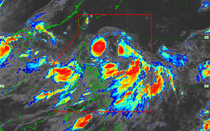
RAINY MONDAY. Tropical depression “Henry” slightly gained speed moving toward extreme northern Luzon on Monday, state weather bureau Philippine Atmospheric, Geophysical and Astronomical Services Administration said. (Satellite image courtesy of PAGASA via PNA)
MANILA— Several areas in Luzon have been placed under tropical cyclone warning signal (TCWS) number 1 as tropical depression “Henry”, slightly gained speed and moves toward extreme northern Luzon, state weather bureau Philippine Atmospheric, Geophysical and Astronomical Services Administration (PAGASA) said Monday.
In its 8 a.m. severe weather bulletin on Monday, PAGASA forecast “Henry” to be over the Babuyan Group of Islands by Monday night.
TCWS 1 is hoisted over Batanes, Ilocos Norte, Cagayan, Babuyan Group of Islands and Apayao. The state weather bureau said occasional rains with gusty winds are expected in these areas.
At 7 a.m. Monday, the center of “Henry” was observed at 440 kilometers east of Aparri, Cagayan.
Aside from “Henry”, the southwest monsoon or “habagat” is also affecting the country.
The provinces of Zambales, Bataan, Cavite, Batangas, Mindoro, Palawan and Western Visayas will experience light to moderate rains due to the southwest monsoon.
Metro Manila and the rest of Luzon will have cloudy skies with scattered rain showers and thunderstorms caused by the southwest monsoon and tropical depression.
Fisherfolk and small sea craft are advised not to venture over the western seaboards of Luzon due to moderate to rough seas.
Temperature in Metro Manila ranges from 24-30 degrees Celsius; Tuguegarao City 23-33; Baguio City 16-22 degrees Celsius; Metro Cebu 25-32 degrees Celsius; and Metro Davao 25-32 degrees Celsius.


