Breaking
Koppu strengthens as it heads toward northeast Philippines; forced evacuations advised
MANILA, Philippines — Typhoon Koppu grew stronger but was moving slower toward the northeastern Philippines late Saturday as the government urged local authorities to issue forced evacuations of residents in flood-prone areas.
Local officials have been advised to conduct the “forced evacuation” of communities historically hit by flash floods and landslides as well as coastal villages at risk from destructive storm surges that could reach as high as 3 metres (10 feet), civil defence chief Alexander Pama said.
“The situation is critical because the winds are getting stronger and it will get stronger as (Koppu) moves closer,” he said.
Regional civil defence chief Norma Talosig said villagers had been voluntarily moving to safer ground or emergency shelters since early Saturday. She could not immediately give the number of evacuees.
Heavy rains are expected to inundate many areas on the main northern island of Luzon even before the typhoon makes landfall early Sunday, acting weather bureau chief Esperanza Cayanan said.
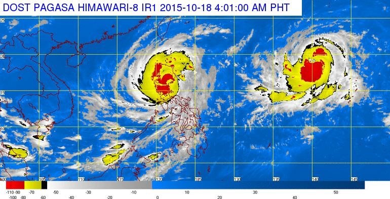
Cayanan said another typhoon farther east and a high pressure area north of the country would hold Koppu in a “semi-stationary” position and shroud most of Luzon with an enormous band of thick rain clouds.
“We are looking at the possible worst scenario, not to scare but to allow us to prepare,” Cayanan said. “If it stays 24 hours … and the downpour is sustained, we will surely have floods and landslides.”
Forecasters said the typhoon’s cloud band had expanded to about 650 kilometres (406 miles) in diameter by late Saturday, unleashing the most intense rain close to the centre.
By 6 p.m. Saturday, the typhoon was about 200 kilometres (125 miles) east of Aurora province, where Koppu is expected to make landfall.
It was packing sustained winds of 175 kilometres (109 miles) per hour, and gusts of up to 210 kph (131 mph). It slowed to a crawl from 15 kph (9 mph) Friday to 10 kph (6 mph). Forecasters said it could grow stronger before it hits land.
AccuWeather said the combination of a typhoon’s slow movement and its powerful winds “could spell a disastrous situation for residents and communities in its path.”
President Benigno Aquino III appeared Friday on national television to warn Filipinos about the typhoon and appealed for co-operation to prevent casualties.
It was the first time Aquino had personally issued a storm warning on television since super Typhoon Haiyan barrelled through the central Philippines in November 2013, leaving more than 7,300 dead or missing.
Aquino said an estimated 1.5 million families, or about 7.5 million people, would need relief assistance.
Metropolitan Manila, the sprawling Philippine capital of 12 million, about 145 kilometres (91 miles) southwest of Aurora, will be spared from the brunt of the typhoon but it is expected to be drenched with intense rain starting late Saturday, forecaster Adzar Aurelio said.
Koppu will likely be equivalent to a Category 3 or 4 hurricane, which could cause devastating to catastrophic damage, according to AccuWeather Meteorologist Adam Douty.
Douty said that 300-600 millimeters (12-24 inches) of rain is expected to be widespread on Luzon, but that certain areas could be inundated by over 900 millimeters (36 inches), which would be “sure to trigger severe and life-threatening flooding and mudslides.”
Koppu will be the 12th storm to hit the Philippines this year. An average of 20 storms pummel the country annually.
– Oliver Teves, The Associated Press


