Philippine News
PH to submit 300-year-old map to UN
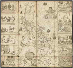
MANILA — The government will submit an almost 300-year-old map to the United Nations Tribunal on the Law of the Sea in The Hague this week.
The move is to back the country’s claims in the disputed Scarborough Shoal being a part of the Philippine territory.
In a VERA Files report authored by Ellen Tordesillas, the said map published by Jesuit priest Pedro Murillo Velarde in 1734 indicates that the Scarbarough shoal, then known as “Panacot” is within the Philippine territory.
It therefore contradicts China’s nine-dash-line which the country has been using to argue its claim in the disputed territories.
The map which measures 1,120 by 1200 mm was acquired by businessman Mel Velarde in an auction at Sotheby’s in London.
The catalog of the said map carries Carlos Quirino’s description which says:
“Murillo Velarde’s map of the Philippines is a landmark in the depiction of the islands, and the first scientific map of the Philippines. It is flanked by two pasted-on side-panels with twelve engravings, eight depicting native costumed figures, a map of Guajam (Guam) and three city or harbour maps, notably Manila.”
Velarde will be presenting the first and certified true copy of the map to President Aquino on the anniversary of the Philippine Independence in June 12.
Reports from Ellen T. Tordesillas, Vera Files


