Breaking
Typhoon Dodong enters country — PAGASA
MANILA — The tropical storm outside the Philippine Area of Responsibility has intensified into typhoon category and entered the country on Thursday, according to Philippine Atmospheric, Geophysical and Astronomical Services Administration (PAGASA).
In an interview, PAGASA weather forecaster Fernando Cada said “Noul” entered the Philippine area of responsibility (PAR) early Thursday morning and was given the local name of “Dodong”, the first tropical cyclone to enter the country this month and the fourth for this year.
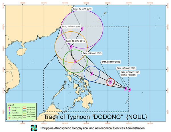
Cada said as of 4 a.m., the center of Typhoon “Dodong” was estimated based on all available data at 1,040 km East of Surigao City (10.2˚N, 135.0˚E) packed with maximum sustained winds of 130 kph near the center and gustiness of up to 160 kph. It is forecast to move West Northwest at 15 kph.
He added that, so far, Typhoon Dodong is not yet directly affecting the country as no public storm warning signal raise in any part of the country. But due to wind convergence on its circulation, the typhoon will bring light to moderate rainshowers and thunderstorms over the regions of Caraga and Davao on Thursday.
Maintaining its speed and movement, typhoon Dodong is expected to make landfall in Isabela-Cagayan area or in Northern Luzon on weekend.
He said once the typhoon continues to gets near the landmass it will bring rains over the Eastern Visayas, Bicol Region and some parts of Luzon including Metro Manila.
Cada also said that so far no gale warning has been issued and fisherfolks are safe to venture into the sea.
For Thursday, Cada said the public will continue to experience warm and humid weather due to Ridge of High Pressure Area (HPA) extending over Luzon.
HPA is the opposite of the low-pressure area – a weather system consisting of warm air circulating over the Pacific Ocean.
He said with the presence of ridge of HPA, the rest of the country including Metro Manila will experience partly cloudy to cloudy skies with isolated rainshowers or thunderstorms.
Despite a warmer weather, he said the occurrence of isolated rains will still prevail due to localized thunderstorms expect mostly in the afternoon or evening.
PAGASA explained that the convective activity brought about by intense heat triggers the formation of more cumulonimbus clouds or dark clouds associated with thunderstorms that brings rains.
He said with the presence of ridge of HPA will bring high temperatures and good weather conditions to the country in the coming days as he advised people to wear lightweight and light-colored clothing, and drink plenty of water.
He said residents of places directly hit by the heat of the sun, without trees, and surrounded by concrete roads would feel much hotter.
On Wednesday, Metro Manila has 34.2 degrees Celsisus recorded around 1 p.
m. at the agency’s Science Garden in Diliman, Quezon City.
For Thursday, temperature in Metro Manila will range 24-35 degrees Celsius while the heat index at 28-39 degrees Celsius.
The heat index are human discomfort index that gives the “apparent” temperature or what human perceive or feel as the temperature affecting their body.
High air temperatures and high relative humidity will give high apparent temperatures or indices. Full exposure to sunshine can increase the heat index by 9°C.
In its advisory, PAGASA said moderate to occasionally strong winds blowing from the East to Northeast will prevail over the Eastern section of Visayas and of Mindanao and the coastal waters along these areas will be moderate to occasionally rough.
Elsewhere, winds will be light to moderate coming from the Southeast and Northeast with slight to moderate seas.


