Breaking
Typhoon ‘Maysak’ expects to intensify into super typhoon as it enters PAR tonight
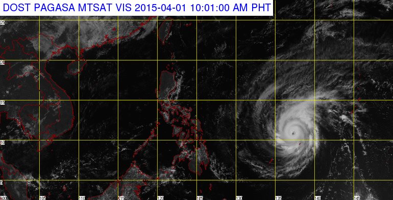
MANILA — Typhoon “Maysak” is forecast to intensify into super typhoon as it enters the Philippine Area of Responsibility (PAR) by Wednesday evening, according to Philippine Atmospheric, Geophysical and Astronomical Services Administration (PAGASA).
In an interview, PAGASA weather forecaster Gener Quitlong said that as of 4 a.m., the eye of Typhoon “Maysak” (International Name) was located based on all available data at 1,410 km East of Surigao City (10.4˚N, 138.4˚E), with maximum sustained winds of 215 kph near the center and gustiness of up to 250 kph. It is forecast to move West Northwest at 17 kph.
He said since typhoon Maysak is still in the sea and outside PAR, it is expected to intensify into super typhoon category with winds of 220 kph.
With its maintaining movement and speed, Quitlong said the typhoon may enter PAR by Wednesday evening and it will be locally named “Chedeng”, the third tropical cyclone to enter the country this year.
He, however, said once it enters it will not yet directly affect the country but will bring rains with winds by Friday or Saturday over the Northern and Central Luzon.
He added the typhoon is expected to make a landfall in Northern Luzon and also affects the eastern side of Luzon due to outer cloud rain bands of the typhoon.
Meanwhile, the country will continue to experience fair weather until Maundy Thursday due to the Ridge of High Pressure Area (HPA) extending over Northern Luzon.
For Wednesday forecast, PAGASA said Cagayan Valley, Cordillera and Ilocos region will experience partly cloudy skies. Metro Manila and the rest of the country will be partly cloudy to cloudy with isolated rainshowers or thunderstorms.
Light to moderate winds coming from the east to southeast will prevail over Northern Luzon, and coming from the northeast over the rest of the country with slight to moderate seas.


