Breaking
Typhoon ‘Ruby’ projected to make landfall Sunday morning; Signal no. 3 still raised in Samar provinces
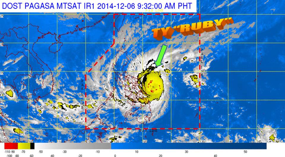
MANILA — Public storm warning signal (PSWS) no. 3 has been raised in three provinces in Visayas as Typhoon “Ruby” continues to threaten Samar provinces on Saturday while maintaining its course and strength, according to Philippine Atmospheric Geophysical and Astronomical Services Administration (PAGASA).
PAGASA weather forecaster Manny Mendoza said that areas placed under Signal No. 3 (winds of 101-185 kilometers per hour expected in at least 18 hours) are Northern Samar, Eastern Samar and Samar provinces.
The Potential Impacts of the Winds under Signal no 3 are:
Heavy damage to agriculture; Some large trees uprooted; Majority of nipa and cogon houses unroofed or destroyed; considerable damage to structures of light to medium construction; Moderate to heavy disruption of electrical power and communication services; and Travel by land, sea and air is dangerous.
Mendoza said as of 6:00 a.m., the eye of Typhoon Ruby was located at 230 km east of Borongan Eastern Samar (12.1 N,127. 5E) packed with maximum sustained winds of 195 kph and gustiness of up to 230 kph.
He said the typhoon continues to move west northwest and decelerated its speed from 13 kph to 10 kph.
PAGASA said that areas under Storm Signal No. 2 (Winds of 61-100 kilometers per hour expected in at least 24 hours) are Catanduanes, Albay, Sorsogon, Ticao Island and Masbate in Luzon; Biliran, Leyte, Southern Leyte, Northern Cebu including Cebu City, Bantayan Island and Camotes Island in the Visayas; and Dinagat Island in Mindanao.
Public storm warning Signal No. 1 (Winds of 30-60 kph is expected in at least 36 hours) is hoisted over Camarines Norte, Camarines Sur, Burias Island, Romblon, Southern Quezon and Marinduque in Luzon; Capiz, Iloilo, Antique, Guimaras, Aklan, Negros Oriental, Negros Occidental, Rest of Cebu, Siquijor and Bohol in the Visayas; and : Surigao del Sur, Agusan del Norte, Surigao del Norte, Siargao Island, Agusan del Sur and Camiguin Island in Mindanao.
The estimated rainfall amount is from 7.5 to 20 millimeters per hour (heavy to intense) within the 600-km diameter of the typhoon.
Mendoza said that if Typhoon Ruby maintains its west northwest movement at 10 kph, it is expected to make landfall Sunday morning over the Eastern Samar–Northern Samar area and will be associated with strong winds, storm surge (3-4 meters) and heavy-intense rainfall.
He said that once ‘Ruby’ makes landfall, the typhoon may also weaken its strength due to friction effect with landmass.
Mendoza added the possibility of its decreased wind strength with the effects of the northeast monsoon, ridge of high pressure and trough of low pressure area (LPA).
“There is possibility the typhoon will further weaken due to the northeast monsoon, ridge high pressure area in mainland China and the trough of LPA in east of japan, ” Mendoza told the Philippines News Agency (PNA).
He said effects of typhoon Ruby and the northeast monsoon will bring rough to very rough sea conditions over the seaboards of Northern Luzon, eastern seaboard of Central and Southern Luzon, seaboards of Visayas and over northern and eastern seaboards of Mindanao.
“Fisherfolks and those using small seacraft are advised not to venture out over the said seaboards,” he warned.
As the typhoon moves closer to Visayas, he said its outer spiral will bring rains in some areas of Luzon including Metro Manila starting Sunday or Monday.


