Breaking
‘Habagat’ to bring rains in Luzon; storm outside PAR intensifies
MANILA — Occasional rains are still expected over Luzon including Metro Manila on Saturday due to southwest monsoon or “hanging habagat” as it continues to be the dominant weather system affecting the Luzon while the tropical storm outside the country has already intensified into typhoon, according to Philippine Atmospheric, Geophysical and Astronomical Services Administration (PAGASA) on Saturday.
The southwest monsoon, which is associated with the occurrence of intermittent to continuous rains, is the prevailing wind system during the rainy season.
For Saturday forecast, PAGASA said southwest monsoon will bring occasional rains over Metro Manila, Calabarzon (Cavite, Laguna, Batangas, Rizal and Quezon), Mimaropa (Mindoro, Marinduque, Romblon and Palawan), regions of Ilocos, Cordillera and the provinces of Pampanga, Bulacan, Tarlac, Zambales and Bataan.
It warned the public of the “high risk” of flooding and landslide in areas in some parts of Luzon.
Continuous rains in the past days increased the risk of flash floods and landslides due to the already saturated soil.
It added the rest of the country will be partly cloudy to cloudy with isolated rainshowers and thunderstorms.
The state weather bureau also issued a gale warning — strong to gale force winds associated with the southwest monsoon — to affect the northern and western seaboard of Luzon.
“Fishing boats and other small sea crafts are advised not to venture out into the sea while larger sea vessels are alerted against big waves,” the agency said.
PAGASA also said moderate to strong winds blowing from the southwest will prevail throughout the entire archipelago and the coastal waters will be moderate to rough.
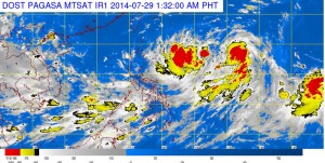
Meanwhile, PAGASA continues to monitor the the tropical storm (with international name Halong) outside the country which has intensified into a typhoon.
As of 4 a.m. the typhoon Halong was located at 1,440 km east of Central Luzon (15.0ºN, 137.0ºE) packed with maximum sustained winds of 120 kph and gustiness of up to 150 kph. It is forecast to move west northwest slowly.
With its movement, PAGASA weather forecaster Samuel Duran said the typhoon Halong is expected to enter the country by Monday or Tuesday.
According to Duran, once it enters the PAR it will be named “Jose”, the 10th tropical cyclone this year and the first tropical cyclone for the month of August.
He added the typhoon is also expected to enhance the southwest monsoon that will induce more rains.


