Headline
Rainy season officially starts; LPA intensify into tropical depression “Ester” – PAGASA

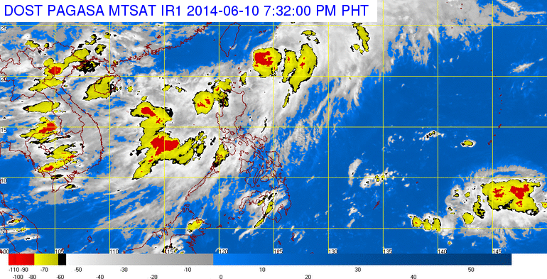
The center of tropical depression “ESTER” was estimated at 200 km north northeast of Basco, Batanes (22.3.0°N 122.7°E) with maximum winds of 55 kph near the center and it is forecast to move northeast at 22 kph. Southwest Monsoon affecting Luzon. Photo courtesy of DOST PAGASA.
MANILA — The Philippine Atmospheric, Geophysical and Astronomical Services Administration (PAGASA) on Tuesday officially declared the start of the rainy season in the country while Low Pressure Area (LPA) near Basco, Batanes has developed into a Tropical Depression named “Ester”.
In an interview, PAGASA weather forecaster Buddy Javier said that all the criteria in declaring the onset of the rainy season have been met.
Javier said that the criteria include the presence of southwest winds and the amount of rainfall is at least five weather bureau stations across the country reached 25 millimeters in volume in five straight days.
In an advisory, Vicente Malano, officer in charge of PAGASA, said that during the next two (2) months (July-August), near (81-120%) to above normal (120%) rainfall conditions are expected in most parts of the country.
He said that during the rainy season, the prevailing weather system is the southwest monsoon or “habagat” and monsoon breaks are likely, which may last for several days.
He added that El Niño will also develop in the next three months (June to August) due to the unusual warming of sea surface temperature.
“Starting September, rainfall patterns in some parts of the country will be affected, ” Malano said.
He said the country is battered by an average of 20 storms per year. With the El Niño, drier conditions but stronger storms are expected.
“PAGASA will continue to monitor the tropical Pacific and updates will be issued as appropriate. Concerned agencies are advised to take precautionary measures,” Malano said.
According to PAGASA, the country’s climate has two major “seasons”, the rainy season from June to November, and the dry season from December to May.
PAGASA divided the dry season into two: a cool dry season (December to February), and a hot dry season (March to May).
Last year, PAGASA officially declared the start of the rainy season on June 10.
Meanwhile, Javier said that the LPA intensified into tropical depression locally named “Ester”, the first cyclone for the month of June and the fifth for this year.
According to Javier, the month of June expects two to three tropical cyclones to affect the country.
As of 10 a.m. Ester was located at 120 km North of Basco, Batanes (21.6°N, 121.7°E) packed with maximum sustained winds of 55 kilometer per hour (kph) near the center. It is forecast to move Northeast at 20 kph.
He added that Ester is not expected to make landfall in any part of the country, and with its speed is expected to be out the Philippine Area of Responsibility (PAR) by Wednesday headed towards Japan.
Javier said that public storm warning signal number 1 was hoisted over the Batanes Group of Islands and Calayan and Babuyan Group of Islands.
PAGASA said these areas will experience winds of 30 to 60 kph in at least 36 hours.
PAGASA advise residents living in low lying and mountainous areas under Signal no. 1 to be on alert against possible flashfloods and landslides.
The Estimated rainfall amount is from 5 – 15 mm per hour (moderate – heavy) within the 250 km diameter of the Tropical Depression.
Javier said that Ester will enhance the Southwest Monsoon which will bring moderate to heavy rains over Ilocos Region and over the provinces of Zambales and Bataan.
”Residents in these areas and local disaster risk reduction management councils concerned are advised to take all the necessary precautionary measures against possible flashfloods and landslides,” PAGASA said.
Meanwhile, small fishing vessels are advised not to venture out into the northern and western seaboards of Luzon.
Tropical depression “Ester” is forecasted to be at 540 km Northeast of Basco, Batanes by Wednesday morning.
It is also expected to be at 1000 km Northeast of Basco, Batanes or outside the Philippine Area of Responsibility (PAR) by Thursday morning.


